By Rail or Road? Comparing Trips to Ontario’s Cottage Country from Toronto. Part One: The Kawarthas
Who doesn’t love to get away during the summertime? For as long as Toronto has existed, residents have sought to escape the hustle and bustle of the city during the summer months to relax at leisure destinations across Ontario. From lakes to beaches to woods, Ontario really has it all when it comes to exploring the great outdoors.
During the first half of the twentieth century, Ontario’s road network was a pale comparison to what it is today. Most of the highways and access roads to cottage country destinations were in their infancy as dirt roads in poor condition. Some of the highways we know well today hadn’t even been constructed yet! At that time, the train was the fastest and most direct way for vacationers to travel. As time went on, more money went towards improving road infrastructure and less went towards rail lines. As railfans and historians know far too well, these rail routes to cottage country were used less and less before being abandoned and removed one by one. Today, only a handful of rail lines access Ontario’s cottage country, and most don’t provide any kind of direct passenger service to these locations.
But what if these old rail routes remained today and were used by more modern locomotives and coaches on upgraded tracks to provide direct service? What I plan to do is outline what a traveler had to do in the year 1940 to travel from Toronto to multiple different vacation destinations by train. I will follow that by comparing that trip in 2022 by car. Lastly, I’ll calculate an estimated travel time by train today if the rails still remained.
I selected the year 1940 for two reasons. The first reason is because I felt it captured railway schedules at a time where the majority of rail lines in Ontario still remained in service, as well as a time before significant changes to passenger schedules in the late fifties/early sixties. It also happens to be the only year in our online data base where I have passenger timetables for both Canadian National and Canadian Pacific passenger trains. I wanted to compare schedules from both railways during the same year in order to have a fair comparison of routes.
There are some additional guidelines and clarifications I need to clear up before we get started. Routes by rail will be from Toronto Union Station to the train station in each community featured. Routes by car will be from the Toronto Railway Museum to a popular hotel or tourist location within each community featured. This will help to even things out with regards to the car being more direct due to door to door travel. Each train selected will be the fastest possible option, using whichever days the trains ran. This is due to some routes not operating trains on Sundays, and other less busy routes only operating on certain days of the week. For road routes, I am calculating the trip duration using Google Maps with a departure time of 5pm on a Friday. This is due to traffic likely being the highest at that point, and reduces some of the advantage the car has with being most direct. Third, for estimating a trip by rail today, I am using the route mileage as they appeared on the 1940 timetable, and calculated time using an average speed of 40 miles per hour. I felt that was a fair average since its in the middle of the speed limits possible on the routes used. Finally, I am only calculating trips to vacation destinations from Toronto, and not return trips. This is being done for both rail and road trips. I am doing this to cut down on words and time, but also due to the fact that many of Ontario’s branch line railways did not operate trains on Sundays. The traditional weekend vacation trip of departing Friday evening and returning on Sunday was typically not an option when travelling by rail, making it impossible to compare rail and road routes in that way. Also, who really wants to think about coming home when on a vacation?
In this part of the series, we will explore the trip to two vacation destinations in the Kawarthas: Bobcaygeon and Haliburton.
Bobcaygeon
Overview: Bobcaygeon is a community of just over 3500 people located on the eastern edge of the former Victoria County, now known as The City of Kawartha Lakes. This town is centred around a cluster of islands between Sturgeon and Pigeon Lakes. Bobcaygeon is popular with boaters who pass through town on Lock 32 of the Trent Severn Waterway. It’s pretty downtown strip boasts many popular shops and restaurants, and the town serves as a gateway community for tourists travelling to Buckhorn, Kawartha Hideway, Kinmount, and Kawartha Highlands Provincial Park.
Railway History: After decades as a remote logging village, Bobcaygeon was connected to Ontario’s rail network when the Lindsay, Bobcaygeon and Pontypool Railway was completed to the town in 1904. There were intentions to extend the rail line past the community, but rough topography meant the rails ventured no further. The LB&P was later acquired by the Canadian Pacific Railway, who operated the line for the remainder of its existence. The route was primarily a resource route to the Canadian Pacific mainline at Burketon, with Lindsay being the busiest community along the line in terms of freight and passenger service. The route was known as the Bobcaygeon Subdivision. Passenger service was reduced to mixed only in the thirties and ceased in 1956. The line continued as a freight only line until the Lindsay-Bobcaygeon segment was abandoned by 1961. The remaining portion south of Lindsay was abandoned in 1987 (check)
It should be noted that when our 1940 time table came into effect, the original southern leg of the Bobcaygeon Subdivision between Burketon and Lindsay had long since been abandoned. By that point, the former Georgian Bay & Seaboard route between Dranoel and Lindsay was being used as the new southern leg of the Bobcaygeon Subdivision. Both the LB&P and GB&S routes branched north of the CP mainline, joining up to run parallel through Lindsay at a point just south of town.
Subdivisions Used: Toronto Terminal Railways & Oshawa Subdivisions from Union Station to Agincourt. Peterboro (now known as Havelock) Subdivision from Agincourt to Dranoel. Bobcaygeon Subdivision from Dranoel to Bobcaygeon.
Target Destination: Our 1940 destination is The Rockland House, a hotel that formerly stood on the south east corner of what is Bolton and Canal Streets today. This hotel stood within walking distance of the Trent Severn Waterway as well as the train station, beach, and other waterfront destinations located within Bobcaygeon. The hotel burned in 1966 and today is the location of Graz Restobar.
Route by train in 1940: There were no direct train options for travellers wanting to go to Bobcaygeon from Toronto in 1940. Only one train by that point, mixed train 605, operated to Bobcaygeon daily except for on Sundays. This meant that the first leg of the journey required passengers to get to Dranoel, the junction point where the Bobcaygeon Subdivision branched off of the Canadian Pacific;s Peterboro Subdivision, now known as the Havelock Subdivision.
Our 1940 timetable shows four possible trains leaving Union for Dranoel: 620, 36, 602, and 34. Trains 602 and 34 can be ruled out as their arrival times of 7:04pm and 1:03am respectively would require a traveler to have to spend the night at Dranoel, a lonely rail junction located in the bush between Millbrook and Bethany, waiting for train 605 to take them north along the Bobcaygeon Subdivision. While one could continue to more comfortable accommodations in Peterborough, it would still mean a two day trip to Bobcaygeon. 620 can also be ruled out as it is a Sunday only train. This means you would only get as far as Dranoel as train 605 to Bobcaygeon did not operate on Sundays. That leaves our final option, train 36. This train departed Union Station at 9:30am and arrived at Dranoel at 11:11am. After a short nine minute wait, a traveler could hop onboard train 605 which took them the rest of the way to Bobcaygeon, with a thirty minute layover in Lindsay. Total time of this journey from Union to Bobcaygeon is three hours fifty five minutes. The total distance of this trip is 96.40 miles, or 155.14 kilometers.
It would have been possible to get an earlier start by taking Canadian National Train 92. This train departed Union Station at 9:05am and would allow travelers to make to Lindsay by 11:15am by taking the Oshawa and Uxbridge Subdivisions. Here one could transfer and catch train 605 at the Lindsay Canadian Pacific Station across town. An hour and twenty minute layover between 92’s arrival and 605’s departure at 12:35pm eats into total travel time, and the total duration of this alternate trip is four hours and twenty minutes, or twenty five minutes slower then the Canadian Pacific route.
Route by car in 2022: If a traveler today wanted to get from our Railway Museum to The Rockland House/Graz Restobar by car, they would first need to access the Gardiner Expressway. This is done by taking Bremner Blvd, turning right onto Lower Simcoe Street, left on Harbour Street, and left onto Bay street. A traveler would then take the Gardiner and the Don Valley Parkway north out of the city to access Highway 401. The 401 takes a traveler through the east part of the GTA until reaching the turn off to go north on highway 35/115 at Newcastle. After about ten minutes, turn left onto the highway 35 cutoff to the outskirts of Lindsay. Here, turn right onto Highway 7 for a quick jog over to Highway 36. Turn left and follow this highway along the eastern limit of Lindsay before snaking for approximately twenty through the farmlands of the former Verulam Township. At County Road 24, turn left, and follow this road into Bobcaygeon.
An interesting fact about County Road 24 between Highway 36 and Bobcaygeon is that it follows the path of the former Bobcaygeon Subdivision mentioned earlier. This allows drivers to access Ancona Point and Keystone Beach, both being locations that were previously only accessible by boat or rail. Highway 36 takes a more southerly route, but can also be used to access Bobcaygeon. While overall duration is about the same, it adds four kilometers to the trip. A driver with time to spare who wants to follow Highway 36 all the way can also take a detour south at Emily Creek Road to view the former Dunsford Canadian Pacific station, now in use as a cottage.
After following County Road 24 over Little Bob Channel into Bobcaygeon, make a quick left and right onto Sherwood and Canal Street West respectively before reaching the intended destination. The total distance by road, using the slightly shorter County Road 24 route, is 164 kilomteters or 109.90 miles. Travel time is estimated at between two hours and two hours forty minutes.
What If Direct Rail Service Was Present Today? The late Derek Boles made reference to numerous Canadian Pacific summer excursion trains, including a special to Bobcaygeon, in an analysis of a Summer 1930 Union Station/North Toronto Station train schedule. A June 24, 1934 Bobcaygeon Subdivision Timetable I came across makes reference to a specialized “Note A/Note B Train” that ran north to Bobcaygeon on June 30th, Aug 4th, and Sept 1st (all Saturdays) and south to Toronto on July 2nd, Aug 6th, and Sept 3rd (all Mondays). Railway historian Charles Heels makes reference to summer excursion trains to Bobcaygeon in his book Railroad Recollections.
What if a direct rail link existed today? We have to play pretend a little bit since a significant portion of the route has been made into a trail or developed over. The 40mph or 64.37 km/h average speed should be a fair estimation even with the moderate but numerous curves along the Havelock and Bobcaygeon Subdivisions, and the slow down required to follow the winding route through Lindsay. In this scenario, track improvements have been done to allow the 40mph average speed to happen (currently the Havelock Subdivision has a set 10mph limit due to track conditions)
The total length of the route from Union to Bobcaygeon is 96.40 miles. 96.40 miles divided by 40 miles per hour equals a 2.41 hour trip or two hours twenty four minutes. This checks out when converted to kilometers, with 155.14 kilometers divided by 64.37 kilometers per hour equaling the same trip time.
Summary: Even with the heavy traffic of Toronto and the GTA, the car route today is a faster option then rail service was in 1940. The numerous stops along the rail route, combined with a transfer to another train, eats up more time then the door to door service offered by a car. Another factor for the rail route is that one would have to then walk from the Bobcaygeon Station to The Rockland House, adding approximately another ten minutes to their journey, unless a carriage ride was possible.
Despite being slower, the rail route is more direct then today’s road network in terms of distance. The route traveled by rail is 13.50 miles, or 48.86 kilometers, shorter then the routes followed by car. If we could bring direct rail service with no stops at an average speed of 40 mph/64.37 kmh, then we would in theory have a comparable trip timewise to the car, with a total travel time of 2.41 hours or approximately two hours twenty four minutes.
| Transportation Option | Travel Time | Route Distance In Miles | Route Distance in Kilometers |
| Travel using trains 36-605 in 1940 | 3 hours 55 Minutes | 96.40 | 155.14 |
| Travel by car in 2022 | Between 2 hours and 2 hours 20 minutes | 109.90 | 164 |
| Direct Point A-Point B rail service using previously existing rail routes | Approximately 2 hours 24 minutes | 96.40 | 115.14 |
Haliburton
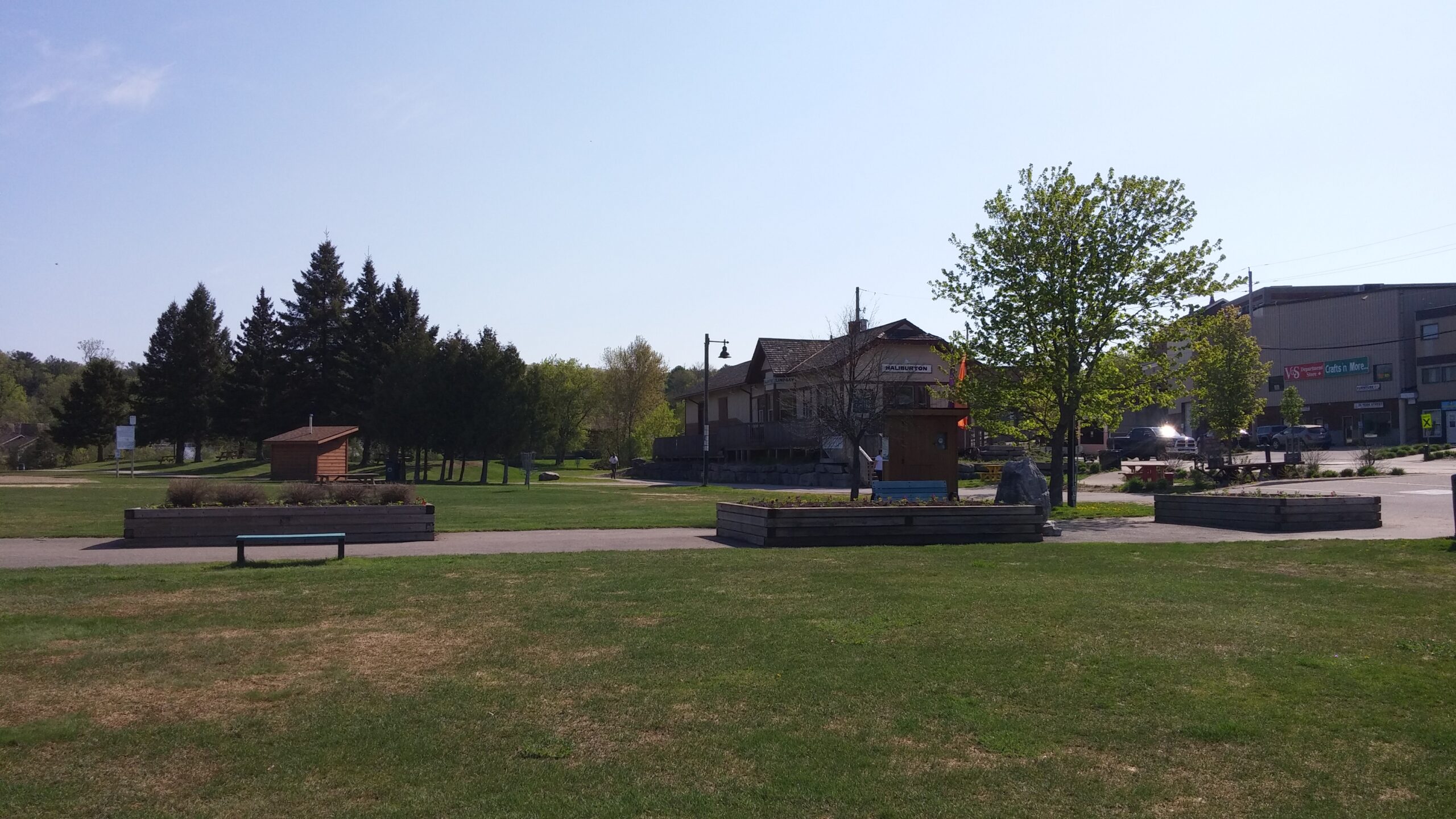
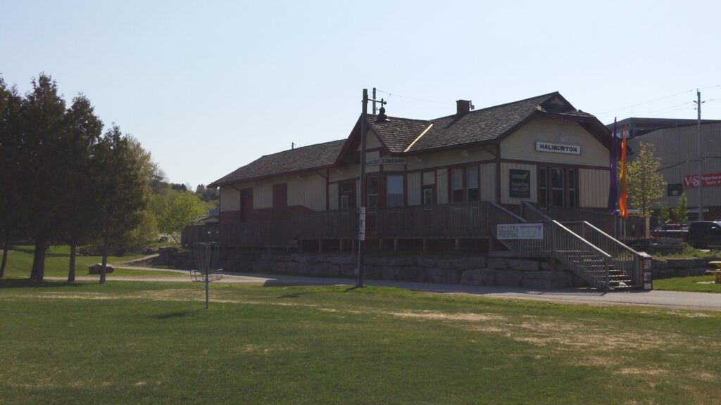
Overview: Haliburton is a village located in Central Ontario on the southern and eastern shores of Head Lake. It is part of Haliburton County, which also includes the communities of Minden, Wilberforce, Dorset, West Guilford, and Irondale. Haliburton sits at the junction of County Road 21 and Highway 118. Its rural and rugged location amongst the Haliburton Highlands makes it a popular destination for cottaging, summer camp, artists, and outdoor sports. I’ve personally had some great outings fishing the numerous lakes within the Haliburton area.
Railway History: Rails reached Haliburton in 1878, four years after the Victoria Railway began constructing its line north from Lindsay. It branched off from the route of the Port Hope, Lindsay, & Beaverton Railway at a point north of Lindsay called Victoria Junction. This segment formed the majority of what later became the Haliburton Subdivision, passing through the communities of Fenelon Falls, Burnt River, and Kinmount on the way to what became its terminus at Haliburton. Later, the line was extended south of Victoria Junction through the town of Lindsay along Victoria Avenue to meet the rails of the newly constructed Whitby, Port Perry & Lindsay Railway, allowing for a more direct connection to Toronto.
The route to Haliburton, the WPP&L, and the Toronto & Nipissing Railway from Toronto to Coboconk, were some of the many branchlines incorporated into the Midland Railway network in the early 1880s. Despite all this new mileage, a direct link from Toronto to Lindsay and Peterborough was not present. The Midland Railway solved this in 1883 by building connecting routes between some of their lines including one between the WPP&L route at Cresswell and the T&N route at Blackwater. This link created what later became known as the Uxbridge Sub, which passed through the community of the same name. The Uxbridge and Haliburton Subdivisions eventually became the most direct route for rail passengers to travel between Toronto and Haliburton. These rails were later acquired by the Grand Trunk Railway, who themselves were acquired by the Canadian National Railway in 1923.
Freight and passenger traffic on the Haliburton Subdivision was consistent but never of a high volume. The majority of trains that serviced the Haliburton Subdivision were mixed trains of freight and passenger cars. The trip was leisurely with potentially long stops at stations while the locomotives tended to freight related duties within each community. Trains operating along the Irondale Subdivision from Bancroft would use the Haliburton Subdivision south of Howland Junction to access Lindsay. These mixed trains continued to ply the Haliburton and Irondale Subdivisions until their termination in 1960.
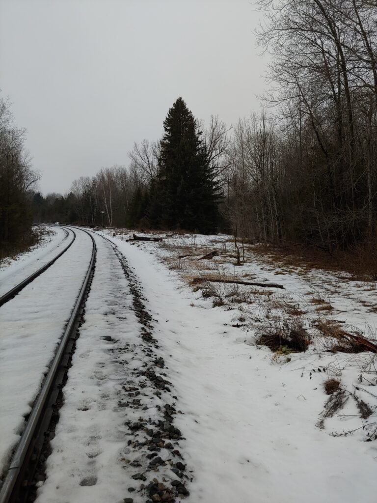
The Haliburton Subdivision remained in freight only usage for just over twenty years after mixed service ended. Frequency of trains gradually reduced throughout the seventies. A washout in 1978 just north of Kinmount spelled the end of service to Haliburton, and the line was abandoned and removed by 1983.
Subdivisions Used: Toronto Terminal Railways and Oshawa (now Kingston) Subdivision from Union Station to Scarboro Junction. Uxbridge Subdivision from Scarboro Junction to Lindsay. Haliburton Subdivision from Lindsay to Haliburton.
Target Destination: Our target location for this trip will be the Haliburton train station. We can do so because the station still stands today at its original location in use as Rails End Gallery and Art Centre. I felt it was appropriate to use the station as our travel location as travelers in the days of trains would only need to walk a few steps to explore both downtown Haliburton and the shores of Head Lake. Drivers today can do the same while parking their car at or near the station. There is no need to account for additional distances on foot like with Bobcaygeon.
Route By Train in 1940: The first leg of the journey is to get to Lindsay from Toronto. In 1940 there were two possible options. Train 92, which left at 9:05am, or train 94, which left at 4:45pm. The latter option would require an overnight stay in Lindsay to catch train 389 for the Lindsay-Haliburton segment of the trip. As quaint as a two day trip sounds, I am looking for the quickest possible rail option. In this case, it’s train 92, which arrives in Lindsay by 11:15am.
Upon arrival at Lindsay, a traveler would have to wait thirty minutes before train 389’s scheduled departure time of 11:45am. Travelers on this train could expect a slow but scenic journey as the train winds through the increasing rugged terrain along the route. Station stops had the potential to be longer then typical as the train switched freight cars at various industries along the way. Some of the scenic highlights along the way included views of Cameron Lake, the Burnt River and Crego Creek trestles, the Austin Sawmill in Kinmount, the distinct bridge over the Gull River north of Gelert, and the Standard Chemical Company at Donald, south of Haliburton. If all went according to plan, passengers would reach the Haliburton station at 3:30pm, ending a six hour and twenty five minute trip from Toronto. The total distance of this trip by rail is 124.85 miles, or 200.92 kilometers.
It’s important to note that the 1940 timetable indicates that train 389 only operated on Mondays, Wednesdays, and Fridays. A traveler would have to plan accordingly in order to not be stuck in Lindsay waiting for the next train.
Route by Car in 2022: The first portion of this trip is identical to the Bobcaygeon trip. Getting to the Gardiner Expressway and the Don Valley Parkway is required to reach Highway 401. This time, instead of heading east on Highway 401, continue north onto Highway 404, taking it all the way to its terminus at Woodbine Avenue south of Ravenshoe Road. Take Ravenshoe Road to Highway 48, and turn left to follow the highway north and then east along the south shore of Lake Simcoe to Highway 12. Turn left onto Highway 12 for about fifteen minutes, and then turn right onto the next section of Highway 48 and follow it to its junction with Highway 35 north of Coboconk. Turn left on Highway 35 and follow it north east to County Road 21, located just north of Minden. Turn right onto Highway 21 and take it all the way into the town of Haliburton. A quick left turn onto York Street is required to take the driver to the train station, located on the north side of York Street.
The total distance of this trip is 216 kilometers or 134.22 miles. Google Maps estimates that the trip would take between two hours forty minutes and three hours forty minutes depending on levels of traffic.
What If Direct Rail Service Was Present Today?: The scenic beauty of the Haliburton area made it a popular destination for excursion trains throughout the 20th century. Keith Hansen, in his book Last Trains From Lindsay, documents trips made by various excursion trains along the Haliburton Subdivision from Toronto in the Haliburton Subdivision chapter of this book. Charles Heels writes about similar trips in his book Railroad Recollections, including special trains transporting children to summer camp. We are again going to use an average speed of 40 mph, or 64.37 kmh, for this estimation. The winding routes of both the Uxbridge and Haliburton Subdivisions might make this speed choice questionable, but for the purpose of estimating, we are assuming we can have both track and rail infrasturce that can handle the above listed average speed. As with the Bobcaygeon trip, this will be a point A-point B trip with no stops in between.
By rail, a train would utilize the Kingston, Uxbridge, and Haliburton Subdivisions to travel from Toronto Union Station to Haliburton. The total mileage of the portions of these three subdivisions used is 124.85 miles. If we divide the 124.85 distance by the 40 mph speed average, we get an overall trip time of 3.12 hours, or three hours seven minutes. Converted to kilometers per hour, we get a 200.92 kilometer distance divided by the 64.37 kmh average speed to get the same 3.12 hour trip.
Summary: Again the car serves as a much quicker option then train service in the 1940s in terms of time. Mixed trains were for the purpose of utility, not speed. While a much slower option, the rail route is arguably the more scenic option with the numerous lakes, large bridges, and rural villages along the line.
Again we see that despite being slow, the rails followed a more direct route then the road network does today. The combination of the Oshawa/Kingston, Uxbridge, and Haliburton Subdivisions is 9.37 miles/15.08 kilometers shorter then the combination of highways needed to reach Haliburton today. If a direct rail option were possible from Toronto to Haliburton, operating at an average speed of 40 mph/64.37 kmh, it is estimated that the trip could be completed in three hours and seven minutes, which is within the estimated range of a car trip to the same location calculated by Google during the Friday rush.
| Transportation Option | Travel Time | Route Distance In Miles | Route Distance in Kilometers |
| Travel using trains 92-389 in 1940 | 6 hours 25 minutes | 124.85 | 200.92 |
| Travel using car in 2022 | Between 2 hours 40 minutes, and 3 hours 40 minutes | 134.22 | 216 |
| Direct Point A-Point B rail service using previously existing rail routes | Approximately 3 hours 7 minutes | 124.85 | 200.92 |
Conclusion
It’s hard to compete with the convenience of being able to travel door to door by car, even if it means having to battle traffic and construction to escape the city. While both the Google Maps trip calculations and direct train service time calculations are estimates, comparing the results of both does suggest that direct rail service could be a competitive alternative to car travel in terms of overall travel time. The rail routes we looked at in 1940 were slightly shorter then the road network used today. I feel that it is safe to hypothesize that having rail routes to Bobcaygeon and Haliburton, with updated track, locomotives, and passenger equipment, would allow travelers to reach those destination in a similar time as it would take by car.
It is important to acknowledge a few factors that prevent a definitive ruling on this hypothesis. First, we intentionally planned car trips at a time when traffic was at its highest to cut down on the time advantage already established. If we take the shorter duration of the averages calculated, or planned the trip at an off peak time, the car is still hands down the faster option. Second, there are too many variables present to get a truly accurate car travel time. Google Maps travel duration is an estimation based on driving the speed limit, but many drivers drive significantly faster (or in some cases slower!) then the speed limit. Also construction, varying traffic levels, accidents, and inclement weather can have unexpected impacts on travel times. Third, we are assuming/fantasizing that the rail routes used can be upgraded with modern technology to produce an average speed of 40 miles per hour. Being an average speed, that would imply trains would be travelling faster then that at points. Is this truly possible though? Unless we actually do the work to relay track and upgrade routes, we will never truly know. If it is possible, what if we increased the average speed to 45, 55, or even 60 miles per hour? Lastly, modern development has made rebuilding portions of these routes next to impossible with out expropriation or major development work. Lindsay in particular poses a problem, since the town has wasted no time building housing subdivisions, roads, and other infrastructure along the routes of the Bobcaygeon and Uxbridge Subdivisions since their abandonment. That being said, you could build more direct routes between Bobcaygeon and Haliburton with even shorter route lengths and travel time. Regardless, it would be a massive undertaking that likely would not be popular with landowners today.
While a lot has been left up to speculation, it has been fun to explore and fantasize about what could be possible with updated railway infrastructure. It has also been interesting to explore how people had to travel to cottage destinations before the increase use of the automobile. I hope you have enjoyed reading this as much as I enjoyed writing and researching. Please keep your eyes out for part two of this series, where a similar study is completed for travel to cottage destinations along the shores of Lake Huron and Georgian Bay
Historical Sources
Boles, D. (2021, January/February). Once Upon A Timetable: Canadian Pacific’s Toronto Passenger Service in 1930. Branchline, 60(1), pp. 3-12
Hansen, K. (1997). Last Trains From Lindsay. Sandy Flats Publications.
Heels, C.H. (1980) Railroad Recollections. Museum Restoration Service.
Rails End Gallery and Arts Centre. (2022). Welcome. Retrieved on August 22nd, 2022 from https://railsendgallery.com/
Remembering The Night The Rockland House In Bobcaygeon Burned. (2022). Kawartha411. https://www.kawartha411.ca/2022/04/13/remembering-the-night-the-rockland-house-in-bobcaygeon-burned/
Sirved. (2022). Graz Menu. Retrieved on August 22nd, 2022 from https://www.sirved.com/restaurant/bobcaygeon-ontario-canada/graz/19264/menus